Bend, Oregon opens onto 1.6 million acres of volcanoes, lava tubes, and twin crater lakes: Here’s what to know
Wikimedia Commons/Gary Halvorson, Oregon State Archives
Deschutes is Central Oregon’s outdoor crown
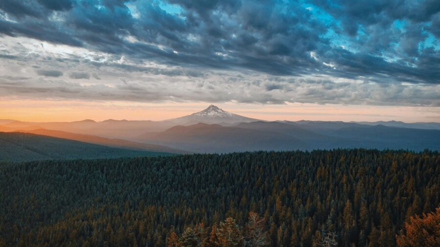
Deschutes National Forest sits just outside Bend, and it is nothing like what you picture when you think of a forest. There are no endless rows of identical pine trees. What you get instead is nearly 1.6 million acres of pine, high desert, alpine lakes, lava fields, and volcanic craters, all in one place. Five wilderness areas. Three scenic byways. A name that means “of the falls” in French. Something unusual waits around every bend in the road. Wikimedia Commons/U.S. Forest Service- Pacific Northwest Region
This land was born from fire and obsidian
Volcanic eruptions shaped every ridge and canyon you see here. Lava flows carved the valleys, cinder cones punched through the ground, and calderas settled into the earth over thousands of years. The forest went official in 1908, managed by the U.S. Forest Service, but Native peoples had been coming here long before that, chipping obsidian from the volcanic rock to make cutting tools. That obsidian is still here, scattered across the land in fields of black glass. Wikimedia Commons/U.S. Forest Service- Pacific Northwest Region
Walk a mile underground through a frozen lava tube
Lava River Cave drops you into darkness about a mile long. The tube formed tens of thousands of years ago when lava from Newberry Volcano flowed through and cooled from the outside in, leaving a hollow channel behind. Bring a jacket. The cave sits at a steady 42 degrees no matter what season you visit, and you walk through it with only your own light cutting through the black. It is one of the longest lava tubes in Oregon, and you feel every foot of it. Wikimedia Commons/Gary Halvorson, Oregon State Archives
Sparkle and crunch across 1,300-year-old volcanic glass
The Big Obsidian Flow is the youngest lava in Oregon. About 1,300 years ago, an eruption covered roughly one square mile of the Newberry Caldera in shiny black volcanic glass, and on a sunny day it still catches the light like a field of scattered mirrors. A one-mile loop trail cuts right through the jagged rock. Interpretive signs along the way explain how the flow came to be. The trail is not long, but the terrain around it does not look like Oregon. It barely looks like Earth.
Wikimedia Commons/Gary Halvorson, Oregon State Archives
Climb to nearly 8,000 feet above the lava fields
Paulina Peak tops out at 7,984 feet, the highest point in Newberry National Volcanic Monument. When the snow clears, a Forest Service road climbs close to the summit, or you can hike it if you want to earn the view. From the top, you can see the caldera below you, lava flows spreading out from the base, Cascade peaks cutting the horizon, and the wide Oregon high desert rolling into the distance. Clear days give you the kind of view that takes a few seconds to process. Wikimedia Commons/Gary Halvorson, Oregon State Archives
Two clear lakes sit inside an active volcano’s crater
Paulina Lake and East Lake fill the floor of the Newberry Caldera, and the volcano that holds them could still wake up someday. For now, the lakes draw paddlers, swimmers, and anglers casting for trout in cold, clear water. Natural hot springs bubble up along parts of the shoreline, so the water temperature varies depending on where you step in. The whole scene, two alpine lakes inside a volcanic crater with steam rising at the edges, is one of those things you have to see to believe. Wikimedia Commons/Another Believer
Watch Paulina Falls split into twin curtains of water
Paulina Falls drops about 80 feet in two side-by-side cascades, and they spill over the lowest rim of the Newberry Caldera. Volcanic cliffs rise on both sides, framing the falls in dark rock. An upper viewpoint sits just 0.1 mile from the parking area, so you don’t have to work hard to reach it. A steeper path drops down if you want to stand closer and feel the mist. Both angles are worth the few minutes it takes to get there. Wikimedia Commons/B J IMAGERY
The tallest waterfall near Bend drops 97 feet straight down
Tumalo Falls hits 97 feet, making it the tallest and best-known waterfall in the area west of Bend. A viewpoint sits just steps from the parking lot, so even a quick stop gives you the full picture. If you climb a little higher, you reach an overlook right at the brink where the water tips over the edge. Keep hiking past that and more falls wait upstream. The trail doesn’t quit after the first one. Wikimedia Commons/Gary Halvorson, Oregon State Archives
A forest of hollow tree molds frozen in ancient lava
About 7,000 years ago, a lava flow swallowed a stand of old-growth trees. The rock cooled fast around the trunks, and as the wood burned away, it left behind hollow molds in the shape of trees. Those shapes are still there. The Lava Cast Forest trail runs one mile on a paved loop through the stone columns, and the path is flat enough for almost anyone. What you walk through is a forest that burned from the outside in and left its shadow behind in rock. Wikimedia Commons/Parker Knight
A cinder cone with a road to the top and views for miles
Lava Butte punched up about 500 feet from the surrounding land roughly 7,000 years ago and buried everything nearby in a sea of jagged black rock. A road spirals to the summit, where a fire lookout gives you a clear view across the lava fields to the Cascade peaks.
Read more from this brand:
You can climb an Oregon volcano with no ropes and find a lake at the top
Oregon’s 30-million-year-old volcanic walls turned rock climbing upside down
This Oregon mountain range has 60 alpine lakes and almost no tourists
The post Bend, Oregon opens onto 1.6 million acres of volcanoes, lava tubes, and twin crater lakes appeared first on When In Your State.
Down at the base, the terrain looks more like a moonscape than a forest. Trails wind through the hardened lava so you can get a closer look at the rock and the scale of what one eruption left behind. Wikimedia Commons/Brett Hansen, U.S. Department of Transportation
A 66-mile drive past peaks, lakes and snowcapped volcanoes
The Cascade Lakes Scenic Byway starts near Bend and runs 66 miles through the core of the forest. You’ll pass Mt. Bachelor, drive alongside South Sister and Broken Top, and roll past dozens of alpine lakes lined up along the route like a string of blue glass. Trailheads and viewpoints come every few miles. The road doesn’t rush you anywhere. It just keeps handing you another angle on the same dramatic landscape, and the views of the snow-capped peaks hold up from start to finish. Wikimedia Commons/U.S. Forest Service- Pacific Northwest Region
Green Lakes, Sparks Lake and a snowy mountain winter
The Green Lakes Trail climbs to a cluster of alpine lakes sitting directly beneath South Sister and Broken Top. Sparks Lake and Todd Lake stay closer to the road, with easy family-friendly paths and calm water good for paddling. On still mornings the surrounding peaks reflect off the surface like a mirror. When snow covers the forest in winter, the whole area shifts into ski and snowshoe territory. Mt. Bachelor anchors the winter side of things, rising over the forest as the region’s main snow hub. Wikimedia Commons/Another Believer
Explore Deschutes National Forest in Oregon
Deschutes National Forest runs along the eastern Cascades just outside Bend, reachable via Highways 97, 20, 126, 242 and 58. The forest stays open year-round, but many high-elevation roads, including the Cascade Lakes Byway and the road into Newberry Caldera, close in winter and typically reopen between June and October. A $5 day-use fee applies at many sites, or you can use a Northwest Forest Pass or America the Beautiful pass. The Green Lakes Trail and other popular wilderness routes require a Central Cascades Wilderness Permit from mid-June to mid-October. Check current road conditions and fire restrictions with the Deschutes National Forest office before you head out. This article was created with AI assistance and human editing. Read more from this brand:
You can climb an Oregon volcano with no ropes and find a lake at the top
Oregon’s 30-million-year-old volcanic walls turned rock climbing upside down
This Oregon mountain range has 60 alpine lakes and almost no tourists
The post Bend, Oregon opens onto 1.6 million acres of volcanoes, lava tubes, and twin crater lakes appeared first on When In Your State.
Leave a Reply