Red, buff and black cliffs stack up in this canyon Sedona visitors skip: Here’s what to know
Shutterstock
A Wild Canyon Sedona Visitors Skip
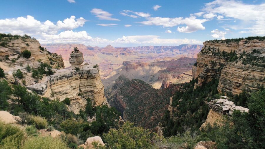
West of Sedona, a canyon almost as big as its famous neighbor sits without a single road running through it. Sycamore Canyon Wilderness spans more than 20 miles along Sycamore Creek, and in places the rim-to-rim distance stretches 7 miles wide. Red sandstone, buff limestone and dark basalt stack up the cliff walls in bands you can trace with your eyes. You won’t find crowds here, and once you learn why, you’ll understand what makes this place work so differently than everywhere else nearby. Shutterstock
Second Only to Oak Creek Canyon
Sycamore Canyon ranks as the second-largest canyon in Arizona’s red rock country, right behind Oak Creek Canyon. It sits in northern Arizona, west and northwest of Sedona, and winds for more than 20 miles along Sycamore Creek. At its widest points, the canyon spreads up to 7 miles between rims. You can trace the layers as you look at the cliffs. Red sandstone sits against buff-colored limestone, and dark basalt cuts through both, giving the walls a striped, uneven look you won’t mistake for any other canyon in the region. Shutterstock
Protected Wilderness Since 1972
Congress set this canyon aside as a wilderness area in 1972, making it one of Arizona’s first protected wilderness areas in the state. The wilderness covers roughly 56,000 acres, and it doesn’t sit inside a single forest boundary. It spreads across three national forests, the Coconino, the Kaibab, and the Prescott, and four separate ranger districts share the job of managing the land. That kind of split management is rare, and it tells you how large and how remote this stretch of canyon country really is. Wikimedia Commons/Coconino National Forest
Your Feet Are the Only Way In
No paved road cuts through this wilderness, and no developed campground sits inside its boundaries either. If you want to see the canyon floor, you hike in or you ride in on horseback. Those are the only two options. The rules keep vehicles and development out, so the land looks close to how it always has. You’ll often walk for hours without passing another group, and that solitude is part of what draws people back here again and again. Wikimedia Commons/Coconino National Forest
Follow Parsons Trail to a Hidden Spring
Parsons Trail follows a stretch of Sycamore Creek that runs year-round, fed by underground springs rather than seasonal rain. The path winds through the lush lower canyon, and after a short descent at the start, the walking turns gentle. You’ll pass deep, clear pools sitting beneath sheer red cliffs before the trail reaches Parsons Spring, the spot where the creek surfaces from underground.
It’s the kind of destination that makes the flat miles beforehand worth every step. Wikimedia Commons/Chrinstine Paulu
A Green Ribbon Cutting Through Dry Country
The canyon floor holds a desert riparian habitat, one of the rarest habitat types found anywhere on Earth. Tall cottonwoods and sycamores lean over the creek and shade the water below. Arizona walnut trees grow along the banks too, adding another layer of green to the scene. Springs seep out from the canyon walls and feed patches of columbine and watercress along the trail. Against the dry, sunbaked country surrounding it, this narrow green corridor stands out the moment you walk into it. Shutterstock
An 11-Mile Loop Along the Rim
Up above the gorge, the Sycamore Rim Trail forms an 11-mile loop that mixes two very different landscapes. Half the route traces the rim high above the canyon, and the other half cuts through forested plateau country. Along the way, the trail climbs KA Hill, an isolated summit that tops out at 7,287 feet. You don’t have to commit to the full loop either. Several trailheads break the route into shorter segments, so you can pick a piece that matches the time you’ve got. Shutterstock
Basalt Pools That Hold Water All Year
Along the Sycamore Rim Trail, you’ll come across Pomeroy Tanks, a set of natural basalt pools that hold water through every season. Small fish live in these pools, and lily pads with yellow flowers float across the surface. Cattails and green grass grow in a ring around the edges of the water. Plenty of hikers who’ve covered the whole loop point to this spot as the prettiest stop along the way, and once you see it, you’ll understand why they say that. Shutterstock
Waterfalls Dropping Over Black Basalt
Sycamore Falls drops over cliffs of black and orange basalt in an area also known as Paradise Forks. The falls run seasonally, flowing strongest after rain or snowmelt higher up in the watershed. Two separate waterfalls sit on opposite sides of the canyon here, each dropping through its own tiered rock face. Rock climbers show up alongside hikers to work these basalt walls, so don’t be surprised if you spot climbing gear at the base when you arrive. Shutterstock
Overlooks With No Trail Required
You don’t need to hike far to take in some of the biggest views in the wilderness. The Sycamore Vista overlook sits high above the point where the upper forks of the canyon meet.
Read more from this brand:
Flagstaff, AZ gave us Pluto and now offers the best stargazing in the American West
Arizona’s Cathedral Wash looks boring for five minutes, then it absolutely isn’t
Sedona’s 7.5-mile road got America’s highest driving honor and earns every bit of it
The post Red, buff and black cliffs stack up in this canyon Sedona visitors skip appeared first on When In Your State.
Nearby, the Sycamore Canyon Overlook opens up a wide view without requiring any trail at all. Soaring cliffs fill the horizon, with the canyon dropping away beneath them. Each overlook along the rim frames the canyon from a slightly different angle, so the view keeps changing as you move along the edge. Shutterstock
Bears, Lions and Birdsong Along the Creek
Black bears roam the wider canyon country here, sharing the landscape with mountain lions and deer that move through the brush and forest. Overhead and along the creek, you’ll hear canyon wrens and hermit thrushes calling back and forth. Bluebirds and hummingbirds dart between branches, while turkey vultures circle high above the cliffs. The mix of desert lowland and forested highland inside one wilderness supports an unusually wide range of animals, all living within a few miles of each other. Shutterstock
One Canyon, Several Climates
Elevation inside the wilderness ranges from about 3,580 feet near the Sedona side up to more than 7,000 feet near Williams. That swing in elevation changes what grows on the ground as you move through the canyon. Lower stretches hold desert plants and chaparral, the kind of scrubby, sunbaked vegetation you’d expect near Sedona. Climb higher toward Williams, and ponderosa pine, Gambel oak and juniper take over instead. Few wilderness areas in Arizona pack this many plant zones into one connected stretch of land. Shutterstock
A Canyon That Still Looks Wild
Wind and water carved seven layers of rock into these canyon walls, stacking red sandstone against white limestone and brown lava rock. That layered record spans a long stretch of geologic time, and you can read it just by looking up. The lack of crowds gives the whole canyon a sense of solitude you won’t find at busier parks nearby. Sycamore Canyon plays the quieter, wilder counterpart to Oak Creek Canyon, and the wilderness rules in place since 1972 keep it looking much the way it always has. Shutterstock
Hit the Trails at Sycamore Canyon Wilderness
You can reach the lower Parsons Trail by turning off the road to Tuzigoot National Monument near Clarkdale onto Sycamore Canyon Road, though a high-clearance vehicle helps once the pavement turns to gravel. For the upper Sycamore Rim Trail and Sycamore Falls, you’ll head out from Interstate 40 near Williams on forest roads instead. There’s no potable water anywhere in the wilderness, and restroom availability changes by trailhead, so carry plenty of water and check current conditions with the Williams or Red Rock ranger districts before you go, especially in summer. This article was created with AI assistance and human editing. Read more from this brand:
Flagstaff, AZ gave us Pluto and now offers the best stargazing in the American West
Arizona’s Cathedral Wash looks boring for five minutes, then it absolutely isn’t
Sedona’s 7.5-mile road got America’s highest driving honor and earns every bit of it
The post Red, buff and black cliffs stack up in this canyon Sedona visitors skip appeared first on When In Your State.
Leave a Reply