Zion’s quiet neighbor is a Utah mesa with cliff views and free camping under the stars: Officials say
Wikimedia Commons/Bureau of Land Management
They call it “The Goose”
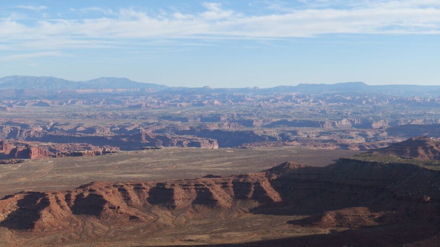
Gooseberry Mesa sits at about 5,200 feet in southern Utah’s red rock country, just west of Zion National Park. Locals call it “The Goose,” and it delivers 18.3 miles of slickrock and singletrack trails across a flat-topped mesa with cliff-edge views in every direction. Zion’s giant sandstone cliffs rise to the north. Colorful desert mesas and carved canyons spread out below the rim. The trails alone would be enough, but what happens after dark out here is something else entirely. Wikimedia Commons/BLMUtah
Two brothers built the first tracks in the ’90s
Brothers Mike and Morgan Harris started cutting trails across the mesa in the early 1990s, long before anyone outside southern Utah paid attention. By 1999, the system became the first official mountain bike trail in Washington County. Seven years later, it earned National Recreation Trail status. The Bureau of Land Management manages the land now, but the mesa itself took about 240 million years of erosion to carve into the shape you ride and hike across today. Wikimedia Commons/Bureau of Land Management
The Point gives you a full 360-degree view
The most famous stop on the mesa is called The Point, and you can see why the moment you get there. The view stretches in every direction. Zion’s cliffs fill the north. Smithsonian Butte rises to the east. The Pine Valley Mountains and Little Creek Mountain frame the west, and the St. George Basin opens up below. If you time it right, a fall sunset turns the whole scene red and gold. Wikimedia Commons/BLMUtah
Follow the white dots across wavy slickrock
The mesa top is covered in smooth, wavy rock that looks like something from another planet. Riders and hikers follow white dots painted right on the surface to stay on route. The rock ripples with red and white bands laid down in ancient times, and short stretches of soft dirt singletrack weave between the stone sections. People describe the terrain as Mars-like, and once you see it, you won’t argue with that. Wikimedia Commons/BLMUtah
Pick your loop from easy to leg-burning
The full network runs 18.3 miles, and you can mix loops to build whatever kind of day you want. The White Trail cuts through the middle and keeps things easy.
The Practice Loop works as a warm-up and a skill check if you’ve never ridden slickrock before. The South Rim is where things get serious, with steep, uneven ground that tests your legs and your nerve. Each loop runs roughly one to three miles, so you control the distance. Wikimedia Commons/Bureau of Land Management
Walk the North Rim above thousand-foot cliffs
The North Rim hike follows cliff edges high above the valley floor, and the path stays mostly flat and easy to walk. That said, the drop beside you is more than a thousand feet, so you feel every step. Juniper trees line the trail and throw patches of shade across the rock. The path ends at a wide viewpoint where the desert opens up in every direction. It’s one of the best walks on the mesa. Wikimedia Commons/Bureau of Land Management
Condors circle over cactus and pine
Juniper, pinyon and ponderosa pines dot the mesa top, and prickly pear cactus and cliffrose bloom across the desert floor between them. Look up and you might catch California condors circling overhead on the thermals. Deer, cottontail rabbits and lizards move through the brush and across the rock. The mix of green against red stone keeps the landscape shifting with every turn of the trail. Wikimedia Commons/BLMUtah
Petrified wood and quartz hide in plain sight
Pieces of petrified wood lie scattered right across the mesa surface, left behind by an ancient forest that once grew here. Along the North Rim, you can spot bits of sparkling quartz catching the light. The mesa sits on colorful layers of very old rock, and every step across it reveals a small piece of deep history. You don’t need to dig or search hard. Just look down as you walk. Wikimedia Commons/BLMUtah
The night sky out here has almost zero light pollution
Once the sun drops, the mesa turns into one of the best stargazing spots in southern Utah. Light pollution is almost nonexistent, and on a clear night, countless stars and constellations fill the sky from horizon to horizon. Photographers set up tripods along the rim, and fall nights bring comfortable temperatures for sitting outside. The quiet is total. No traffic, no glow from town, just you and whatever is overhead.
Read more from this brand:
Utah’s only pink dune field sits between red cliffs and juniper trees near Kanab
Between two tiny Utah towns sits a dirt road with a ghost town and green stone
Moab is the only town in America where two national parks fight over your attention
The post Zion’s quiet neighbor is a Utah mesa with cliff views and free camping under the stars appeared first on When In Your State.
Wikimedia Commons/BLMUtah
Camp for free with views of Zion at sunrise
You can camp right on the mesa for free, and the dispersed sites sit among juniper trees with wide desert views in every direction. Wake up early and Zion’s cliffs and Smithsonian Butte glow in the first light. There are no hookups, no reservoirs and no crowds. It’s primitive camping at its best, and it makes a budget-friendly base for exploring the whole area without fighting for a spot inside the park. Wikimedia Commons/Bureau of Land Management
Skip the Zion crowds and come here instead
Zion National Park draws massive crowds, and during peak season, you can spend more time waiting in lines than hiking. Gooseberry Mesa sits under an hour’s drive away, and you trade all that traffic for solitude and silence. The same red rock beauty is on full display, but you might have an entire trail to yourself. If you want room to breathe and a place that still feels wide open, this is where you go. Wikimedia Commons/Bureau of Land Management
Few places pack this much into one mesa top
Gooseberry Mesa rewards everyone who makes the drive. Bikers get trails that rank among the best in the country. Hikers get cliff-edge paths with views that go on for miles. Photographers get light that changes by the minute, and campers get free sites under some of the darkest skies in Utah. The scenery competes for your attention at every turn, and the remote setting makes every visit feel like you found something most people missed. Wikimedia Commons/BLMUtah
Hit the trails at Gooseberry Mesa near Hurricane, Utah
You can reach Gooseberry Mesa from Hurricane, Utah, about an hour southwest of Zion National Park. Take Smithsonian Butte Road and follow the dirt roads to the trailhead. A high-clearance or 4×4 vehicle works best, and you should skip the drive when the roads are muddy. Bring plenty of water and sun protection, because there is no drinking water and shade is scarce on the mesa. Fall brings mild temperatures and color across the desert. This article was created with AI assistance and human editing. Read more from this brand:
Utah’s only pink dune field sits between red cliffs and juniper trees near Kanab
Between two tiny Utah towns sits a dirt road with a ghost town and green stone
Moab is the only town in America where two national parks fight over your attention
The post Zion’s quiet neighbor is a Utah mesa with cliff views and free camping under the stars appeared first on When In Your State.
Leave a Reply