This trail between Mount St. Helens and Mount Adams ends at a wall of falling water: Officials say
Shutterstock
The Falls Between Two Washington Volcanoes
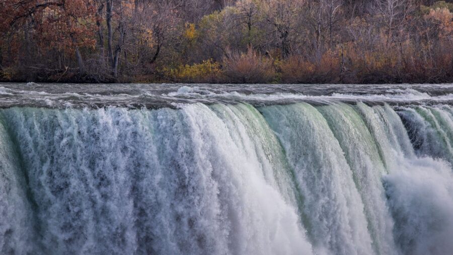
You come around a bend in the Gifford Pinchot National Forest and the trees open onto a wall of falling water wider than a football field. Lower Lewis River Falls sits deep in the woods between Mount St. Helens and Mount Adams, and the curve of the cliff makes it look even bigger up close than it does in any photo. This is only the first waterfall on the trail, and it might not even be the best one. Wikimedia Commons/Jeffhollett
Watch 200 Feet of Water Fall 43 Feet
Lower Lewis River Falls drops about 43 feet over a face that stretches close to 200 feet across the Lewis River. That width puts it among the widest and most powerful falls in Washington. The falls sit deep inside the Gifford Pinchot National Forest, tucked into the country between Mount St. Helens and Mount Adams. The cliff curves just enough to throw off every camera angle. You stand at the rail and the water looks bigger than any picture ever shows it. Wikimedia Commons/jhvanwa
Salmon Once Stalled Out Right Here
Signs near the falls lay out the site’s early history. Before any trail existed, this stretch of river was a prime salmon-fishing spot for Native Americans. The 43-foot drop stopped salmon from swimming any farther upstream, so fish gathered in the pool below by the hundreds. The Lewis River that carved this falls starts as glacial melt running down Mount Adams, and the falls carry the same name as the river that shaped them. Wikimedia Commons/jhvanwa
The Falls Look Different Every Season
Spring brings the fullest version of Lower Falls, when high water covers the entire cliff face in one solid curtain. As summer goes on, that curtain breaks apart into separate channels running down the rock. Most of the flow ends up churning through a trough on one side of the falls. By late summer, the water thins out enough to show the shape and texture of the rock face underneath. Visit twice and you’ll see two different waterfalls in the same spot. Wikimedia Commons/jhvanwa
Wade Into the Green Pool Below
The pounding water has carved out a deep pool at the base of the falls, and the water inside runs clear with a green color that catches your eye from the trail.
That pool has turned into one of the more popular swimming holes in the region. On hot days, swimmers wade straight out toward the falling water, close enough to feel it hit the surface. A cool mist drifts off the pool, carried by a breeze that moves across the water even in summer. Wikimedia Commons/jhvanwa
A Few Hundred Feet to the Rail
From the day-use parking area, you only need a few hundred feet of trail to reach your first look at the falls. A short, easy loop connects several viewpoints, and the route stays gentle enough for hikers of any age. Wooden stairs lead you down toward the river at a couple of spots, putting you right at the edge of the water. Each viewpoint shows a different angle of the falls, so the width and power hit you differently depending on where you stand. Wikimedia Commons/pfly
Middle Falls Spreads Out Over Bedrock
Keep walking upstream and the trail brings you to Middle Lewis River Falls, a drop of about 33 feet spread over several tiers. This one claims the title of widest waterfall along the entire river. The water fans out across a broad sheet of bedrock instead of funneling into one channel. Half of it plunges straight down while the other half slides along the rock at an angle, so you get two different types of falls happening side by side in the same view. Wikimedia Commons/jhvanwa
Upper Falls Tops Out at 58 Feet
Push a little farther upstream and you reach Upper Lewis River Falls, which drops 58 feet across a face 175 feet wide. It stands as the tallest of the major falls on this stretch of river. The shape looks a lot like Lower Falls, just scaled up, with the same wide curtain of water pouring over rock. A lower viewpoint near the base gives you a spot to sit and rest by the water before you head back down the trail. Wikimedia Commons/Walter Siegmund
Spot Trillium, Coralroot and Gnome Plant
Spring covers the forest floor here with bright white trillium blooms, and carpets of vanilla-leaf spread out between the tree trunks. Keep an eye out for stranger plants too, like pinesap, coralroot, and gnome plant, all pushing up through the moss in odd little clusters. Ferns and mushrooms crowd in around them, filling every gap in the ground cover. If you like plants you’ve never heard of, this stretch of trail turns into its own kind of scavenger hunt between waterfalls. Wikimedia Commons/NullSynapse
Take the Quarter-Mile Detour to Copper Creek
Near Middle Falls, a short side path breaks off toward Copper Creek Falls, and the quarter-mile detour is worth every extra step.
Read more from this brand:
Deep in Olympic National Park, a river splits into three waterfalls inside old-growth forest
The clearest lake in Washington state has a secret waterfall hiding just past the trailhead
This tiny Washington town has no lake — just a volcano, ice caves, and wild huckleberries
The post This trail between Mount St.
A bridge crossing puts you face to face with the falls, no scrambling or guesswork needed to find the right angle. Lush green plants crowd the banks around the water on both sides. Most hikers stick to the main trail and miss this one entirely, which makes it a solid reward for anyone willing to take the extra turn. Shutterstock
See One Falls or All Three in a Day
Lower, Middle, and Upper Falls all sit along the same riverside trail, so you can plan your day around seeing just one of them or all three. Most of the crowd sticks close to Lower Falls, and the trail thins out fast once you head upstream. Each falls has its own shape and character, from the wide curtain at the bottom to the tiered spread in the middle to the tall drop up top. Along the way, the river gives you plenty of spots to stop, sit, and reach down into the water. Wikimedia Commons/U.S. Forest Service- Pacific Northwest Region
A Cool Escape Worth the Whole Hike
The mix of falling water, drifting mist, and moss covering every log and stump makes this stretch of river feel like its own separate world. Shade from the old-growth canopy and easy access to the river turn the area into a cool refuge on hot summer days. Photographers and nature lovers keep coming back for the same reason, and the family-friendly paths mean hikers of any age can join in. Somewhere between the trailhead and Upper Falls, you stop checking the time and just follow the water. Shutterstock
Visiting Lower Falls Day Use in Washington
You’ll find Lower Falls in the Lewis River Recreation Area of the Gifford Pinchot National Forest, off Forest Road 90 about 26 miles east of Cougar. The Forest Service manages the site, and the Lewis River Trail runs straight from the day-use area to the water. Bring a Recreation Pass for parking, and book online ahead of time for visits between June 15 and Labor Day. Cell service does not reach out here, so download maps first, pack your own water, and check alerts. This article was created with AI assistance and human editing. Read more from this brand:
Deep in Olympic National Park, a river splits into three waterfalls inside old-growth forest
The clearest lake in Washington state has a secret waterfall hiding just past the trailhead
This tiny Washington town has no lake — just a volcano, ice caves, and wild huckleberries
The post This trail between Mount St. Helens and Mount Adams ends at a wall of falling water appeared first on When In Your State.
Leave a Reply